CHAPTER 4
The Rocky Mountain Irrigation System
photo: elbertprepp.com
Dorp
and Sam traveled north by east. A breeze pushed them up to the
Rockies near Colorado Springs.
About three in the afternoon, they
went over the continental divide. Sam asked Dorp what was going to
happen next.
“Up
to now, Sam, you’ve seen water in nature. Soon, you’ll see water,
nature and humans working together. We’re nearing a water-powered
electrical plant AND a multi-state irrigation system. Both
irrigation and power generation start with the snow on this
mountain, Mount Elbert, the highest peak in Colorado. At high
altitudes, snow begins to accumulate while you’re still sweating,
playing baseball on Labor Day. That same snow may not completely melt
until the next 4th of July.”
“This
is a big Mountain. I have a joke. Why don’t mountains get cold? “
“I
don’t know, Sam. Why don’t mountains get cold?”
“Because
they wear their snowcaps. Hey! Look at all the big rocks sitting
loose on top of this mountain.
Some are bigger than my dad. I didn’t
know that mountains had loose rocks on them.”
Dorp
spoke like a tour guide: “They do on level spots like this. Quite a
sight, no? This mountain is a
14er, as mountain aficionados would say. That means it’s at least
14,000 feet tall. Mt. Elbert is in the state of Colorado, which was
once part of the Louisiana Purchase, bought from France in 1803. Mt.
Elbert was the biggest mountain that America owned at the time,
though the native inhabitants had known about it for a long time. The
snowmelt that comes down the east side of Mt. Elbert in the spring becomes a part of the Arkansas River. It’s about to rain.
Let’s see where that puts us.”
“Whoa
cowboy,” Sam interrupted, “Why is a river in Colorado called the
Arkansas River?”
“Sam,
the Arkansas River was first spotted by white men where it empties
into the Mississippi River. That is in what is now the state of
Arkansas. The name ‘Arkansas’ has to do with a native tribe that
lived near the river where the white man first saw it. So, they named
it the Arkansas River. The Arkansas River actually begins here near
Leadville, Colorado and empties into the Mississippi River, about
1,500 river-miles away.
Sam
was confused, “Wait! You said the Arkansas River flows from
Colorado, which is west to East. I thought rivers flowed from north
to south. What gives?”
“Generally
speaking, yes, water flows toward the equator. In the northern
hemisphere, that means north to south. But water flows downhill,
no matter what direction ‘downhill’ happens to be, Sam. In this
case, it can be from west to east too.
Okay
Sam: time to get wet, so to speak. We’re going into the river and
go downstream to see if we can become irrigation water. This will be
like a ride in the water park for you. That is, if we’re not pulled
into the underflow.”
“What
is ‘underflow?”
Dorp
explained: “All moving waters lose part of their water into the
ground they flow over. If they flow over rocks or concrete, the loss
is minimal, into the cracks. If the water flows over ground with a
clay in the soil, the ground can become saturated and seal up pretty
well. However, in arid areas, where the water is needed most, the
ground is often very sandy, which makes it porous like the beach. It
drinks up a lot of water.
“Where
does the water go, Mr. Dorp? “
“Down;
it percolates into the water table.”
“Is
that like an aquifer?”
“It
can be, Sam, depending on its size. Every aquifer is a water table,
but not every water table is an aquifer.
A water table is a warehouse
of water hidden underground.”
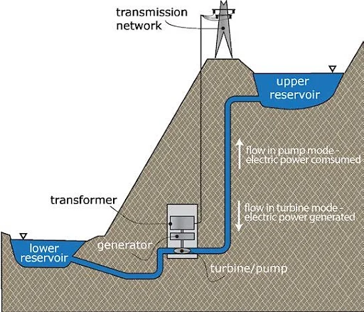
The
vapors over the mountain condensed and Sam and Dorp became rain. They
dropped into Mt. Elbert Forebay,
a manmade catchment
(artificial lake) built to
hold water for the Mt. Elbert Power Plant. The water is discharged
from the Forebay down to the powerhouse where two Francis
turbines turn electrical
generators that create 100 Mega-watts of electricity each. These
turbines are machines that create electricity from water. A different
kind of turbine takes power from a jet engine and turns it into air
power and makes planes fly.
In the 1840s, A Massachusetts lock and
canal engineer named James Francis refined a couple of turbine
designs from the 1820s and made the water turbine 90% efficient. (You
thought the turbine was a modern machine, didn’t you?) The turbines
of that time turned river currents into mechanical power to grind
grain and cut lumber. Dorp
and Sam rode the water slide from the Forebay through one of the
turbines and helped spin it around. Then they sat there until dark and were pumped by the same turbines back up into the catchment.
“What
is going on here? Sam asked. If were supposed to be generating
electricity, we just wasted a lot of electricity getting pumped
uphill back into the same lake we came out of, didn’t we?”
Sam
didn’t understand the economics of 'timed power generation'. During
daylight hours, when Sam and Dorp first turned the turbine to make
electricity, the power company sold that electricity for a certain
price. Electricity is cheaper at nights, because many factories and
businesses are closed. During the night, this power station buys
cheaper power from the grid to pump that same water back up into the
catchment so it can turn the turbine again and make more electricity
that will be sold for a higher price during daylight hours, when
businesses and factories use lots of electricity. The people that run
this power station know that their water supply is limited to snow
melt. So they reuse it. They recycle water to make electricity.
Pretty clever, no? Yes!
But then Sam voiced a thought, "What happens when a lot of electric cars need to charge their batteries at night?
Won't that raise electric fees for everyone, and make places like this out-of-date?"
"We will have to wait and see, Sam."
After
a few trips up and down ‘the turbine trail’, Dorp and Sam were
pushed into Twin Lake, and then into the Arkansas River nearby. While
they were traveling down the river, they saw solar heat and wind pick
up other molecules of water from the river and become airborne.
About
100 miles to the southeast of the power plant on the Arkansas River
is a town called Canon City, Colorado. The ten miles of the river
upstream of Canon City (pronounced 'Canyon City') is a stretch of river called the
Royal Gorge. Sam and Dorp
made it to the Royal Gorge and were being churned around when they
hit a large rock in the stream and were splashed onto the bow of a
river raft filled with weekend-adventurers. That stretch of river is
a magnet for tourism.
“Wow!”
Sam said. “Now I know what it’s like being in a washing machine.”
“Yes,
I’ve had a few trips through washing machines, and usually find it quite agitating,” Dorp deadpanned.
“Why
is the water so rough here, Mr. Dorp??”
“Gravity,
a narrow riverbed, and big rocks make for the kind of ride we have
on this stretch of the river.
The first reason is gravity.
Water is a liquid, it tries to stay as low as it can, so it presses
tightly to the bottom of the river. The Arkansas River drops over 300
feet in the ten-mile-long strip in the Royal Gorge, so the water is
busy trying to stay low.
Second, remember the big rocks on Mt. Elbert? There are also big rocks in the Arkansas Riverbed that
the water has to flow past.
Third, the high sides of the
gorge make a narrow path for the water. The narrower the
channel, the faster water flows."
"Look up Sam, see the bridge coming up above us? That is the Royal Gorge Bridge that so many people come to see.
You get to see it from the river."
Suddenly,
the raft nosed-dived into the water and sprayed everyone on board and sent Sam and Dorp back into the river. They went downstream. The
river calmed down near Canon City, because the river widened out
there, making for a gentler, slower ride. They
traveled down the river for many, many miles.
After a few days, they
neared Garden City, Kansas. They were pulled out of the river by a
diversion weir
and sent down an irrigation intake, a water off-ramp in the river. They parted ways with the
Arkansas River.
A
diversion weir is a low obstruction across a river or stream that
raises the level on the river slightly at that point. This allows
water to be diverted into a canal or channel to irrigate fields.
They
went into a deep, wide canal. As they moved down the canal, there
were ‘head gates’ that diverted the ‘ditch water’ as it is
called, into smaller canals that fed directly into nearby farms, or
into secondary feeder ditches that might travel for miles before
reaching the proper field.
Both were quiet for a while, then Sam spoke “I’ve been thinking;
plants need water, and I guess the farmers have to pay for this
water. How do they know how much water they need?”
“Good
question, Sam. Each type of crop needs a certain amount of water at
each phase in its life. The amount of water each crop needs also varies
according to soil type, amount of wind and the sunlight the plant gets. These
calculations are called 'transevaporation rates'. This is how much
water transpires out of a plant as it grows, plus how much water
evaporates out of the soil during the growing season. Even the type
of irrigation affects the amount of water needed, because some
methods of irrigation are more efficient than others.
Dirt ditches
lose more water to seepage than concrete ditches, for example.
Scientists and farmers alike have been studying this topic for
decades and have mathematical formulas to determine how much water is
needed for each field.
Long
story short, it is calculated in acre-feet.”
“What
is acre-feet, Mr. Dorp? I didn’t know land could walk.”
“Bad
Joke, Sam. I have a farm joke for you. How do dairy farmers count
their herds? With a COWculator.
And how do they know which day it is?
With a COWlendar.
Anyway, the US uses the acre
as a way of measuring land. An acre is 43,560 square feet, about the
size of a football field, without the end zones. Imagine a football
field covered with water, one foot deep. That would be 1 acre-foot of
water, which is 325,861 gallons of water.”
“Those
are terrible jokes, and that would also be one very wet football
field,” said Sam.
“Can you imagine playing football in a field
with a foot of water in it? Wow.”
“While
it may seem like a lot of water, Sam, absorb this: Each acre of corn
in around Kearney, Nebraska needs a little over 2 acre-feet of water
to make a crop, whereas alfalfa in parts of California can
require over 4 acre-feet of water to grow.
This shows the need for
accurate formulas and calculations, especially since about 15% of US
croplands are irrigated.”
“Then
why do they grow alfalfa instead of corn, if corn takes less water?”
“This
has to do with the soil type and other factors. Alfalfa doesn’t
need to be replanted every year, and it is used to feed milk cows. California has a lot of cows. and need hay. Here we go, we’re going to be
diverted through another headgate. Let’s see if this is where we go
to work or if this is a long-distance supply canal.”
They
slipped though the headgate as easily as chocolate milk though a
boy’s straw. Dorp went on to explain more about irrigation. First,
there are two sources for the water; surface water brought in by a
ditch company, or underground water pumped out of an aquifer.
Irrigation methods include surface
irrigation, as water is
applied directly to the surface of the dirt, either by flooding
the area, like an alfalfa field, or row
irrigation, where water is
sent down prepared trenches between the row crops. The second major
type is sprinkler irrigation, accomplished though overhead
sprinklers, which are fed with underground or reservoir water,
brought from an irrigation canal. The very last type is
micro-irrigation,
which uses tubing laid either on the surface or underground to water
the plants.
“Which
type of irrigation is the best?” Sam asked.
“That
depends on what types of crops the farmer is raising, the source of
the water, and how much money the farmer has.
Some systems require
less labor to operate but are very expensive to buy in the
beginning. Irrigating with siphon tubes is a lot of work, but it’s
less expensive than a pivot sprinkler system.”
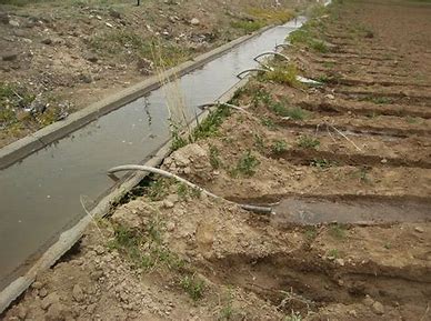
Dorp
and Sam then hit a head gate and were put in field ditch at the upper
end of a corn field. They were going to irrigate corn; or so they
thought. As they poured down the ditch with hooptillions of other
dorps (hooptillions is my word), they saw that the farmer had set a
temporary dam made of plastic tarping attached to a metal pole. The
pole lay across the top of the ditch and the tarp hung down and was
secured at the bottom with a few shovels of dirt. As the water filled
the ditch behind the plastic dam, the farmer began ‘setting the
tubes’. The tubes, nearly as long as the farmer was tall, were
already laid out in a row for the so the farmer could prime them
quickly.
As
the ditch filled behind the dam, the farmer put the long side of the
double-bend siphon tube in the ditch water and made special moves
with his hands to get the water to come out the other end of the
tube. He then quickly laid that end of the tube in the row lower than
the level of the ditch water. Gravity kept the water flowing through
the field, between the rows of corn. The lower the siphon tube was
from the level of the ditch water, the faster the water flowed.
The
more tubes used, the lower the water in the ditch flowed, which meant
less water flowed through each tube. The tubes had to be adjusted so
the water flow would balance amongst the rows. After all the tubes
were set, it took a couple of trips down the head of the field to get
the flow ‘just right.’
Sam
and Dorp sat in the final supply ditch for a while, then were sucked
up through one of the first tubes he set, close to the temporary dam.
The ride through the tube was like being at a water park.
“Sam,
we’re flowing down the field now. It looks like we’re going to
make it to the end the row. Let’s see if we are absorbed by
the corn or evaporate into the air.
Either way, we’re off on a new adventure.”
The
adventure was more than they imagined. While they were sitting in a
little pool of water at the end of the row, a barn swallow swooped
down for a drink and took Sam and Dorp off with her.
“Well.
I wonder where this will lead us. But, not to worry Sam. Even if we
go clear through the bird, it takes far less time to go through a
bird than through a horse.”
“That’s
small consolation,” Sam moaned. “I guess I’m destined to be
bird poop on someone’s windshield.”
They
slid down the bird’s throat, and past a sack in the bird’s
throat. Sam asked what that sack in the throat was.
Dorp
explained, “That’s the bird’s crop.
It is a storage sack in the throat. Small birds may be eaten by other
creatures.
These weaker birds usually eat seeds and insects. A seed
bird can fly into a dangerous area and gather more food than it can
digest right away. This food goes into the bird’s crop. The bird
flies back to safety, where its crop will gradually push the food
into the stomach where it will be digested. The first chamber in the
stomach is called the proventriculus.
It is the chamber where acid is released and food is broken down.
The
second part of the stomach is called the ventriculus,
or gizzard, as it is commonly called.”
“Oh,
so the grain crop goes into the bird’s crop? HA! Wait…Oh! I
love fried chicken gizzards,” Sam gushed. Grandma Tessie makes
them whenever I visit. She batters and fries them like regular
chicken. Even dad asks for them now when we visit.”
“The
gizzard is a very specialized piece of biology. The bird ingests
grit, sand, or small pebbles and they go into the gizzard. Then when
the bird eats seeds, grains, or even hard-shelled bugs, which are
tough to digest, the gizzard acts like a grinding mill and pulverizes
the seeds and grains so the intestines can absorb nutrients from
them.”
Dorp
and Sam made their way through the barn swallow’s digestive tract,
and found themselves not on a windshield, but deposited in a nearby wheat
field, where a light rain washed them into the sandy soil and they
were absorbed by the wheat plant. They became part of the wheat crop, which
holds 10-15% moisture.
This
happened a week before harvest time. They were harvested by a huge
combine, hauled to the mill, milled into flour, bagged and sold to a
grocery distributor. Dorp and Sam wound up in a grocery store in
Guymon, Oklahoma.
dorpwet.com
CHAPTER 4
siphon tube irrigation system
Photo: Old Iron - tractor magazine