CHAPTER 9
On the River
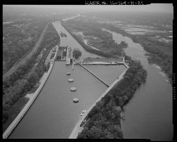
A lock on the river
Dorp and Sam were on their way to New
Orleans and the Gulf of Mexico.
They passed through the Chicago
Sanitary and Ship Canal. They went through the lock (see photo of similar lock) that lowered them
several feet from the Sanitary Canal into the Des Plains River. They
soon entered the meeting place
of the Des Plains and the Kankakee
Rivers, where it became the Illinois River. This puzzled Sam.
“How
can we be in the Illinois River? You said the Illinois River emptied
into the Arkansas River when we were in Kansas”.
“Actually
Sam, there are four rivers in the US named the Illinois River.”
Sam’s
eyebrows knitted up in confusion. “Is that legal?”
Dorp
said: “There is no law against it that I know of. While each state
in the US has a unique name,
this is not true of rivers or
towns.
There are 37 cities and towns in the US named Lincoln, with 12
Lincolns just in the state of Wisconsin.
Not all of them were named
after Abraham Lincoln. There is a Lincoln in England much older than
President Lincoln.
In fact, one of Abe's ancestors may have been named after that town in England."
"Many towns in the English US colonies were named
after English towns. And England is not the only country that
supplied names for American towns and cities. There are over a dozen US cities or towns named Paris, though none are west of Wichita, Kansas. Again, Wisconsin has two of them.”
“Wow,”
Sam said. “So, a guy could be on a car trip; fall asleep in Paris,
Texas and wake up eight hours later, in Paris, Tennessee. Why are
there no cites named Paris west of Wichita?”
“I’ll
leave you to study that when you get home, young man.”
“More
homework. If this keeps up, I’ll learn more this summer than I did
all last year at school.
So, you said there are four Illinois Rivers
are in the US?”
“That
is correct, Sam; one in the state of Illinois,
one in Oregon, named
by miners from Illinois.
One that runs in the states of Arkansas and
Oklahoma, named by a French explorer.
One in northern Colorado."
"This
Illinois River is completely within the bounds of the state of
Illinois. It is about 275 miles long and used to be a major supplier
of buttons for the clothing industry.”
“Excuse
me? “Buttons?”
Dorp
explained: “Before the invention of zippers and plastics, people
used shellfish to make buttons to fasten their clothes.
Immigrants
from Europe, who made buttons from animal horns back home, learned to
cut coin-shaped discs out of mussel shells pulled from river. This
industry employed thousands of people along the Mississippi River
basin.”
“My
grandma has a big metal can full of buttons from her mother. I’ll
bet some of them are shell buttons.”
“Most
likely, Sam, especially if they were made before WW I, and are
whitish and pearly-shiny.”
“Hey,
I have a joke, Mr. Dorp. A woman in a restaurant called the waiter
over.
The waiter asked: ‘What’s the matter ma’am? Is there a
fly in your soup?’
She said: ‘No; there’s a button in my jacket
fries’. Whoo-hooo!”
“Really,
Sam?”
Sam
was triumphant over his latest joke. “Yup, and Oh, what is a river
basin?”
“A
river basin, also called a watershed
or drainage basin,
is the area of land whose rain and snowmelt is collected into a
particular river. While the Mississippi River is about 2,300 miles
long, its watershed is about 1.2 million square miles of land. This
is about 40% of the US land mass”.
Sam
sorted this information: “So once the land ‘sheds’ its water of
excess rain or snow, it goes into a river and into an ocean?”
“Usually,
but not always, Sam. There are two types of watersheds, exorheic
drainage basins and endorheic drainage basins.
Exorheic drainage
basins eventually empty into an ocean or a sea.
Endorheic basins are
either in a desert area and the desert drinks the water before it can
make it to the sea, or the water basin doesn’t produce enough water
to get to an ocean. There might also be natural barriers, like
mountains, that keep the water from getting to the ocean.”
“Don’t
those areas with high boundaries eventually flood?” Sam asked.
Dorp
explained that lakes can exist in these areas, but there is no
outflow. Eventually, the water either evaporates into the air, or
percolates down through the ground to an aquifer below. The Great
Salt Lake is such a system and is typical of endorheic basins. Minerals accumulate because they can’t flow to the ocean and can’t
evaporate with the water.
This is why the Great Salt Lake in Utah is
so salty."
“How
long till we get to New Orleans?” Sam asked.
“It
is about 1,400 miles from Chicago to New Orleans. The Mississippi
River travels at speeds from 1.2 miles per hour at its source, to 3
miles per hour at New Orleans, in normal flows. The river can move 10
miles per hour during a flood.
But if we calculate an average speed of
2.5 miles per hour, it will take us about 23 days to get to New
Orleans.”
“Really?”
What will we do for that long?” moaned Sam.
“Sam,
we have no control over that. We just are. Besides, we’ve been
going for three days already. It takes about 4 ½ days total to reach
the confluence
of the Illinois and Mississippi rivers. This is close to the town of
Grafton, Illinois, a town of about 700 people. Grafton had a
population of 10,000 in the 1850s when fishing was better and there
was a shipyard in town, and the limestone mines were busy before
concrete became common.
“Really?
So why do they not make buttons from shells anymore? Wait; what is a
confluence?”
Dorp
said, “A 'confluence' is where two rivers come together. They come
together because gravity and the terrain made them want to use the
same piece of land to run downhill. The two streams, creeks or rivers
join together and become bigger. Sometimes the new river keeps the
name of one of the old rivers, and sometimes it gets a new name.
But
also, I see you’re still stuck on that button topic.
It is now more
economical to make buttons from plastic. Plus, many rivers are now
too polluted to sustain the marine life necessary to make the mollusks for buttons.
Chemicals coming in the water kill living things in the water."
“Where
does this pollution come from?”
Dorp
answered, “Industrial wastes, agricultural and lawn runoff, and
effluent from city sewage treatment plants.”
“Mr.
Dorp, why does Chicago take its drinking water from the Great Lakes
and empty it into the Mississippi River?
“Sam,
Chicago learned a lesson that still plagues humanity today. The human
digestive tract is a one-way street and the end should not meet the
beginning. When body-wastes mingle with drinking water, people get sick and can die. Fecal
matter (poop) can contain
deadly germs, like cholera and typhoid. These two diseases killed
millions of people in the 1800s. Stephen Douglas, Abraham Lincoln's opponent in the 1860 Presidential election, died in Chicago in
1861 from typhoid fever.
Although Chicago had fewer deaths than other
places, they built the Chicago Sanitary and Ship Canal to keep their
sewage away from their fresh-water supply. This was before they learned how to better purify sewage.
“But
what does that do for the towns downstream?”
“This
is yet another human conflict that comes from people having to share
water.”
“A
day and a half until we reach the Mississippi River? Where will we
spend the night?
“Oh,
Sam, we’ll spend tonight and several more in the river. This life
is my unending fate unless I am changed back into the gases of oxygen
and hydrogen.”
“Do
you ever wish you could be changed back?”
“I
would still be going through people, plants and animals. The only
difference is that as a gas it would be harder to trap me or freeze
me. Though…If I became liquid oxygen, I could help propel a rocket
ship and then spend forever in outer space, doing absolutely nothing.
“How is it I can miss food
when I can’t get hungry?"
"Humans
have traits called habits. Once a human does something for a few
times, something in them wants to do it regularly. This is a good
thing if it is a job skill, but it is a bad thing if it is an
addiction. You certainly can change subjects in a hurry."
Dorp
and Sam approached Grafton, Illinois, where the Illinois River and Mississippi rivers run parallel like railroad tracks,
for about five miles before
joining confluencing (my word).
This strip of land is named
Calhoun County, also called ‘The Kingdom’ by locals.
Dorps call
it ‘The Illinois Peninsula’.
Sam saw a flat boat called a ferry
with cars and people going across the river from one riverbank to
the other.
There
is a 37-mile stretch of the Illinois/Mississippi River, from East
Hardin to Alton, Illinois with no bridge across the river. Bridges
that cross large rivers cost a lot to build. The Mississippi River,
for example, is about 2,300 miles long and has just 220 bridges
across it. This doesn’t meet everyone’s needs, so ferries still
have a place in modern life.
New York City is a series of islands and
has a ferry system that many non-locals just call the Staten
Island Ferry.
That fleet of ferries give 3-4 million rides per year.
They
floated past Grafton and joined the Mississippi River at Island 526.
They were nearly to St. Louis, Missouri.
On the north end of the
city, they came upon the confluence of the Missouri and Mississippi
Rivers.
Dorp
spoke: “Well Sam, the Upper Mississippi River began in Minnesota
and ends here in St. Louis and thus begins the Middle Mississippi
River.”
They
floated through St. Louis and saw the Arch approaching, just above
the Eads Bridge.
(Actually, they were approaching the Arch. The Arch
pretty much stays where it is. That’s the way people like it.
It’s
easier to visit the Arch when it stays in one place).
“If
you had a great, great arm, you could throw a baseball through the
Arch right now and it would land in the stadium where the St. Louis
Cardinals play. Between the diamond and the Arch is St. Louis
Community College, which I’m sure has lower class attendance the
days the Cards play a home game.”
“I
wish we could stop and see a game, Mr. Dorp. Man. That Arch is a lot
bigger than it looks in pictures.”
Dorp
gave Sam the details: “It’ is 630 feet tall, 630 feet wide, and its
shape is called a 'weighted catenary.'
A pure catenary resembles the
shape of a chain hanging by its ends; a very graceful, very strong
design. The catenary is used as a structural design by architects;
especially in bridges.”
“Hey!
I learned something in school. The word architect has the word ‘arch’
in it!“
“That’s
right, Sam. The discovery of the arch was the key to building
structures with openings that were self-supporting.
It’s one thing
to build a wall. It’s quite another thing to be able to get through
the wall, especially if the wall is part of house. Arches placed
end-to-end are called arcades,
arches built side-to-side are called
vaults,
and arches in a circle are called domes.
Bridges, which are
critical to our road system, rely on arches to carry loads across
rivers and ravines.
They
passed through St. Louis and continued south and west. They managed
to not be evaporated by the breezes and winds that blew up and down
the river, or by the sun that shone directly above the river, pulling
hooptillions of other water molecules out of the river.
But they were
ingested and released a few times by channel catfish.
“So
that’s what a catch and release feels like,” Sam said. “There
are so many creatures here in the water that I have never seen
before. I guess it’s because we are so small now, I can see them. A
little bluegill looks like a stadium.”
“That’s
right, Sam. Things that were once too small to see when you were a
boy, are now big enough to eat you.”
“I
have a joke. What state does the Mississippi River flow in? “
“It
flows in a liquid state.”
“That’s
actually clever. Now I have a riddle for you. There are three pairs
of states that touch each other, both geographically and
alphabetically. They are all east of the Missouri River. Can you name
them?”
“Not
without a map to look at. Sigh. More homework.”
Dorp
announced: “Big event coming up soon. We are nearing Cairo,
Illinois, about to be joined by the Ohio River.
Look! the Ohio River
is actually larger here than the Mississippi River.”
“The
Ohio River. And does the Ohio River begin in Ohio? Please, oh please,
tell me that it does.”
“Sorry
Sam. The Ohio River begins in Pennsylvania, and acts as a watershed
for water from the states of Ohio, Indiana, Virginia, West Virginia,
Kentucky, Tennessee, North Carolina, Pennsylvania, and even New York.
The name Ohio, given to both the river and the state, was an Iroquois
Indian name that meant ‘good water.’”
“Aargh,
matey.” Sam said in his best pirate voice. “I see. So is the Ohio
River joining the Mississippi River, or is the Mississippi River joining the
Ohio River?”
“Good
question. It is here that the Mississippi is labeled the
Lower Mississippi River. If
we go strictly by size, called the largest
branch criterion, the Lower
Mississippi should be called the Ohio River, but it isn’t.
Incidentally Sam, there are no locks, dams, or complete blockages of
the river between here and New Orleans, about 1,000 miles away.”
“Another
thing that might interest you; Up the Ohio River is a town called
Kenova, West Virginia. Its name is 'portmanteau',
a combining of two or more other names. Kentucky, Ohio and Virginia gave Kenova its name. Other portmanteaus
are Delmarva, Georgalina, Illiana, Arkmo, Idavada.”
They
passed several cities and towns on either side of the bank. After a
time, Dorp pointed out a loop in the river near the boot heel of
Missouri, by a town called New Madrid. Though not a big city, it still has very special place in American history and in geological
studies.
New Madrid, Missouri was first settled by a group of
Spanish explorers in the 1700s, hence the name. But what is important about this town is what is underground, where we can’t
see.
This area of land where Missouri, Illinois, Kentucky, Arkansas,
and Tennessee sort of come together, sits on a spot called
The
New Madrid Seismic Zone.
Several earthquake faults pass through this area. In the winter of
1811-1812, there were multiple earthquakes here that liquefied the
topsoil in the area and opened holes in the river that swallowed
entire boats and islands in the river.
It spit chunks of coal and
sulfur into the air, raised and lowered different sections of the
river, and made part of the Mississippi River run backwards for a
time at the speed of a trotting horse. One survivor said his boat was
pushed four miles back up the river.
The earthquakes rang church
bells as far away as Boston, and Reelfoot Lake was created in nearby
Tennessee.
Naturalist
James Audubon was in the area at the time of this event and wrote
about riding his horse in Kentucky through the tremors. Relatives of
the Presidents Roosevelt were killed on a steamboat near here and
some thirty flatboats and crews were lost, apparently disappearing
into the holes in the river, never to be seen again.
When
Dorp told this to Sam, he was amazed: “People just disappeared? The
river spit out chunks of coal? From underneath the ground?”
“Yes,
Sam, eyewitnesses said the river ran black with coal dust in some
places. There were also several waterfalls created that the river
soon eroded smooth again. And this problem isn’t over. Seismic
experts feel this will happen again, perhaps creating problems on a
national level. Several bridges and underground pipelines in the area
could be destroyed.”
Sam
did a facepalm. “Well, this is certainly a happy turn of events. I
thought the Midwest was safe from things like tsunamis, but now I’m
not so sure.”
They
continued downstream and meandered toward the Gulf of Mexico,
sometimes going south, sometimes going east, sometimes going west,
and sometimes going north through an oxbow, but always going lower in
elevation.
They passed the city of Osceola, Arkansas. Dorp noted that
twenty-one states have a town or a city named Osceola,
probably after
a White/Creek Indian who lived with the Seminole Tribe in Florida and
took part in the Seminole uprising in 1835. He was arrested when he
thought he was going to Georgia to talk terms of a peace treaty. This
betrayal angered even fully white Americans, which may be why so many
towns were named after him. Wisconsin has one town named Osceola.
Just
above Memphis, Tennessee, Dorp pointed to the west and said, “Behold
the state of Tennessee.”
Sam
challenged Dorp: “I know my geography better than that. Tennessee
is on the east side of the river
and Arkansas is on the west
side of the river.”
“Not
completely, Sam. In March of 1876 on this spot at Reverie, Tennessee,
the Mississippi River straightened itself, cutting through an oxbow.
That place is now named the Centennial Cut-off. Reverie, Tennessee
then didn’t know which state it belonged to, since it was now on
the Arkansas side of the river. The US Supreme Court decided in 1918
that state boundaries should not be moved if a river changes its
flow. This is why it is still Reverie, Tennessee, not Reverie,
Arkansas. “
“When
you get home, look in your atlas and see just how many boundaries are
formed by water, which helps bring peace.
Many wars between tribes,
peoples, and nations have been prevented by the presence of both
still and running waters. People seem to respect established waters,
often more than they respect the people that live on the other side
of the water.”
“Now
off we go to Memphis, Tennessee, the biggest city on the Mississippi
River.”
“Why
is a loop in the river called an oxbow?” asked Sam.
“Humans
have long used animals to do work for them,” Dorp explained. They
use dogs to help them herd their flocks.
They use horses to carry
them faster and farther than they can run. They also used oxen to
pull wagons and farming implements. Oxen are a special type of
cattle, specially adapted to pulling loads. They are hooked to their
loads by a linkage called a harness.
The oxen are connected to this
linkage by a half-round wooden piece around their necks. This piece
is called an oxbow.
It is shaped like a bow that is bent way back to
shoot an arrow. Ox-bow, eh?
A loop in a river looked a lot an oxbow to pioneers
going west.”
“I
have a joke. Why are rivers rich? Because they have two banks. Are we
almost to Memphis? Thank you very much.”
A
history of Memphis for our readers:
Memphis, way back, was explored by
both the Spanish and the French. Spain had a fortress here at one
time. Memphis has long been a major shipping point for products
grown, logged, and mined east and southeast of Memphis. Their
products were shipped down the river as far away as New Orleans. This means that boats from other countries bring and
carry away products and people around the world.
In the early days,
producers used flat boats
that went with the current, often all the way from Ohio to Natchez,
Mississippi, or New Orleans, Louisiana. Abraham Lincoln made a couple
of these trips from Indiana to New Orleans, where he witnessed a
slave auction.”
Sam
saw a steam-powered paddle boat.
“Look at the big boat!” shouted
Sam. “I’ve seen them in our history book. Do they really still
use those? “
“Absolutely,
for tourism. That is a sternwheeler.
“Why
is it called a sternwheeler?” Sam asked. “Does it frown all the
time?”
"No, its paddlewheel is in the rear of the boat, also called the stern.
The stern-wheeler and the side-wheeler are two types of steam-powered
paddle-wheelers that have traveled American waterways since the
1780s. Robert Fulton made upstream-power travel viable by building a
practical steam engine. Before steam power, many rivers could only be
traveled downstream, or upstream by rowing, real hard work.
With the
steamboat, settlements were begun in the white man’s west. Old
remote settlements turned into cities. Steamboats pushed up the
Missouri River, even to places like Yankton, South Dakota; Bismarck,
North Dakota, and Bozeman, Montana.”
“Hmmm,”
Sam thought. ‘I could have written an advertising jingle for them:
(Sam
sang) “‘Up stream travel-no longer a dream; go upstream with
steam, yeahhh.’
Wait; then did steamboats do away with flat
boats?”
“Not
at first. Before the steamboats, the boatman’s trip back home could
take 3 months to walk. Abe Lincoln went to New Orleans on a flatboat,
then bought a ticket home on a steamboat and made it home in a
matter of days. Eventually, the faster steamboats on the river
reduced shipping prices and made flatboats impractical. After that,
people just floated down the river for adventure.”
“Then
why are the steamboats no longer regularly running?” asked Sam.
“Steamboats
replaced flatboats. Steamboats helped develop new towns upstream on
the many rivers that fed the Mississippi. But after steam-powered
boats helped open the west to white people, steam-powered trains
followed behind and moved people and freight faster, and to more
places than steamboats could go, especially once they learned to
build railroad trestles over rivers and gullies, using the principle
of the arch, I might add.
Sam
thought, “I’ve read Huck Finn. I would like to do that one day.”
“Sam!
Think! You’re doing that right now. You just don’t have a boat
and don’t have to concern yourself with a water accident.
Speaking
of Mark Twain; he, Faulkner and others wrote books set on the
Mississippi. Several country and blues artists have written songs
about this river. Poems have also been written about it. It is a
central part of life in Middle America.
On to New Orleans and the
Gulf of Mexico.
A
few miles south, Dorp looked east and pointed out the Mississippi
Delta to Sam.
“Do
you mean were at New Orleans already, Mr. Dorp?”
“No,
I said Mississippi Delta, not Mississippi River Delta. They are two
different places and two different ecosystems.
The boundaries of the
Mississippi Delta
are the upper third of the state of Mississippi, and from the Yazoo
River to the Mississippi River. The Mississippi
River Delta is a few hundred
miles south yet. I know this might be confusing to your boy-brain,
but there is a difference.”
A
couple of days later, Sam and Dorp became entangled with a plastic
bag in the river. Sam became quite irritated because the bag was tan
and they could almost see through it, but not quite.
Dorp commented
on Sam’s attitude.
“Having
trouble? Don’t you like being trapped in a plastic bag?”
“No, I don’t!” Sam yelled. Why am I stuck in this stupid bag where I
can’t see? Why is this bag even in the river?”
“Why
Sam, haven’t you ever lost control of a plastic bag when you are
out running errands? Haven’t you ever taken something out of a bag
and then the bag blew away?”
“Well
yes,” Sam said. “but I don’t throw plastic bags in the river.
That’s littering.”
“True,”
said Dorp, “but many of the bags that get blown away end up in the
nearest waterway and eventually find their way to the oceans of the
world. The wind even takes bags from landfills and carries them to
the water.
“Then
what happens to these bags, Mr. Dorp?”
“Just
like toilet paper congregates in the middle of the toilet bowl before
it disappears in a flush, plastic bags find their way to the center
of an ocean because of currents. Every ocean and major sea have what
is called a garbage patch,
where the plastic collects. These garbage patches can be several
square miles in size and are made not only of stuff dumped from
ships, but mostly from bags like this, that blow away.”
“How
do we get out of this mess?”
“We
hope the currents and eddies in the river will twist the bag, so we are
freed. But even so, many dorps are trapped in plastic bags in the
water, and many water creatures die in these bags. I find it
interesting that many people who claim to be environmentalists use
plastic bags.
They
got out of the bag three days later and floated generally south
several more days. Sam was glad to get out of the bag.
It was like
wearing sunglasses at night; hard to see anything.
About 125
northwest of New Orleans, they approached a confluence of two rivers
north of the town of Simmesport, Louisiana.
“What’s
this place about?”
“Most
of the time when two rivers join, one is called a tributary
because the smaller river feeds the larger river.
Not here. This Red
River mingles with the Mississippi River without emptying into it.
Instead, The Red River and part of the Mississippi River join and
form the Atchafalaya River and head south by west while the rest of
the Mississippi River heads south by east to New Orleans.
Rather than
being a tributary,
it has become a distributary
of the Mississippi River. The Mississippi River wants to shift its
waters to the Atchafalaya River and take that
river over and follow its course.”
Sam
asked, “Why is that?”
“Well,
remember that water always follows the course of least resistance.
You have seen the dry oxbows where the river bypassed inefficient
curves in the land. The Mississippi River wants to do the same thing here,
which would isolate Baton Rouge and New Orleans.”
They
continued and soon enough were in New Orleans.
“I
wish we could stop and get a muffuletta,”
Sam said, even though he
couldn’t get hungry, he still had the habit for eating. Eating took
up a lot of his boy-life.
You could tell by the family grocery bill.
“Maybe
someone in that cruise ship will throw you part of a crust. Even a
crumb would be hugely bigger than you.
How do you know about
muffulettas?”
“My
folks watch cooking shows. I see a lot of food I’ve never eaten.
Look at the cruise ship. I didn’t know that cruise ships came to
New Orleans.”
“Some
do, Sam; those that carry about half the passengers of the really big
ones. Look seaward.
We are about to enter the Mississippi River
Delta.”
“The
Delta-delta?” Sam asked suspiciously.
Photo: Pinterest

CHAPTER 9
bayou
photo: worldatlas.com